
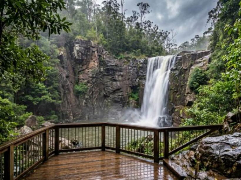

Bean Creek Falls drops about 25 metres in a single fall on Bean Creek, south of Urbenville in northern New South Wales. You'll find it down a signposted side road off the drive through Yabbra State Forest. From the car park, it's a short, steep walk down to a fenced viewing platform. Come after rain, when there's water going over the edge.
If you're driving Clarence Way between Urbenville and Bonalbo and wondering whether it's worth the turn-off, and whether your car will manage, this is for you.
After the small roadside Bean Creek Falls in White County, Georgia, USA? That's a different waterfall, on private land beside Bean Creek Road.
| Location | Falls Road, Bean Creek NSW 2469, south of Urbenville |
|---|---|
| Height | About 25 m, one drop (World Waterfall Database) |
| Type | Horsetail waterfall |
| Turn-off | About 20 km from Urbenville, towards Bonalbo |
| Walk | Short and downhill, steep steps at the end |
| Road | Dirt at the end, rough in places |
| Cultural note | Sacred to the Gidabal people (Visit Kyogle) |
Where Is Bean Creek Falls?
It's in the Kyogle region, on the road from Urbenville down to Bonalbo. Visit Kyogle, the council's tourism site, puts the signposted turn-off on your right about 20 km out of Urbenville.
The drive in is half the reason to come. Visit Kyogle rates the eucalypt scenery through Yabbra State Forest among the best on the north coast. It also mentions bellbirds in the canopy and rainforest walks signposted off the road.
Save the trailhead coordinates before you go, in case the phone drops out: −28.572641, 152.580307 (ExplorOz).
How Do You Get to Bean Creek Falls?
Leave Clarence Way and follow the signs along Mills Road, then Falls Road (Aussie Bushwalking). According to Visit Kyogle, the falls are 700 metres down a dirt track, with a small car park nearby.
Take the last bit slowly. A visitor who went in January 2022 said the final few hundred metres were badly chewed up and a bit iffy in a 2WD. That's one driver on one day, not an official road rating, and we can't tell you what it's like now.
Picture yourself in a small hatchback after a wet week. You'd probably do better to pull over before the worst of it and walk the rest. It only adds a few minutes. To check ahead, ring the Kyogle Visitor Information Centre on 02 6632 2700.
The Short, Steep Walk to the Viewing Platform
It's quick. Aussie Bushwalking calls it more of a stroll down to the waterfall than a real walk.
It's steep, though. ExplorOz says the track runs downhill most of the way, then finishes with steep steps to a fenced platform. From there, you look straight across at the falls and down into the waterhole. Palms crowd the creek banks, bright green against the grey-green eucalypts.
Before the steps, a side track drops steeply to the creek above the falls, and ExplorOz warns it's dangerous. With a 25 m drop just downstream, stay on the platform.
How far is it?
Nobody publishes an official track length, so we worked it out from ExplorOz's coordinates. The trailhead is roughly 245 m from the falls in a straight line, and about 17 m higher.
- North–south: the latitudes are 0.002196° apart, and × 111,000 m per degree that's about 244 m.
- East–west: barely anything, about 13 m.
- Height: 288.65 m − 272.04 m = 16.61 m.
The path bends, so you'll walk more than 245 m. It's still short, though the steps could be tough for anyone who struggles on stairs.
A Sacred Gidabal Place
Visit Kyogle notes that the falls are sacred to the Gidabal people. Keep that in mind from the moment you arrive.
We couldn't find published rules about what you can and can't do at the falls. So behave as you would at any culturally significant site. Keep to the track and platform, carry out everything you bring in, and leave nothing behind. If you want to know more, the visitor centre is the place to ask.
When Is the Best Time to Visit Bean Creek Falls?
After rain. Aussie Bushwalking says you'll see the waterfall from the platform once there's been some rain, which suggests it thins out in dry weather.
But rain cuts both ways. What fills the falls can also churn up the dirt road. Our guess is that a few days after steady rain gives you the best of both. That's reasoning, not data, since we couldn't find any flow records for Bean Creek.
What to Check Before You Go
A few things people usually ask about aren't published anywhere we could find:
- Facilities: Visit Kyogle mentions a picnic area. We couldn't confirm toilets, tables or bins.
- Swimming: There are no published rules. Given the site's significance and the steep ground above the falls, we'd leave it.
- Dogs: We couldn't confirm whether dogs are allowed on the track.
- Phone signal: Unknown, so download your maps first.
One call to the visitor centre should sort most of these out.
FAQ
How tall is Bean Creek Falls?
Bean Creek Falls is about 25 metres, in one horsetail-shaped drop, according to the World Waterfall Database. The database says some of its heights are estimates.
How long does the walk to Bean Creek Falls take?
A few minutes each way for most people. The trailhead is only about 245 m from the falls in a straight line, but leave time for the steep steps at the end.
Can you get to Bean Creek Falls in a 2WD?
Probably, if you take it slowly. The last stretch is dirt and was rough when one visitor drove it in 2022. After heavy rain, call the visitor centre first.
Can you swim at Bean Creek Falls?
We couldn't find any published swimming rules. Because the falls are culturally significant and the ground above them is dangerous, we'd suggest enjoying them from the platform.
It's a short turn-off for a 25 m waterfall, a waterhole ringed with palms, and a forest drive Visit Kyogle rates among the north coast's best. Worth the stop.
Go after some rain, crawl the last bit of road, and treat the place with care.