
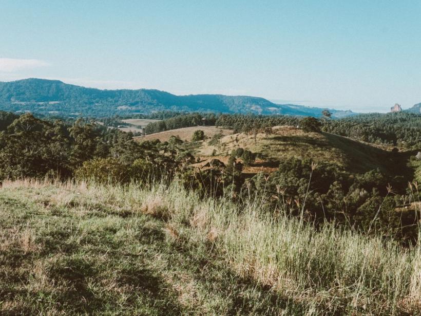
What are Nimbin Rocks and where are they
Nimbin Rocks are a set of jagged volcanic plugs formed from rhyolite, a hard lava that cooled inside ancient vents roughly 20 million years ago. The surrounding softer rock eroded away over time, leaving the tall spires you see today rising abruptly from the valley floor.
The formations sit on private land along Nimbin Road, about 3 km south of the village centre. You can spot them clearly from the roadside lay-by, though there is no public access beyond that point. The three main spires dominate the skyline and look especially striking in the early morning or late afternoon light.
For the Bundjalung people, the rocks are a sacred men’s initiation site and carry deep cultural significance. They feature in local dreaming stories and are protected under Aboriginal heritage laws. When you stop to photograph them or simply take in the view, keep to the designated roadside area and respect the signs that mark the boundary.
Can you walk up to or climb Nimbin Rocks
No, public access to the rocks themselves is not permitted. The site is fenced and signposted as private property held by the Bundjalung people under Aboriginal land rights legislation. Walking past the fence or attempting to climb the formations is both trespassing and culturally insensitive.
The rocks are a registered Aboriginal Place under NSW law, recognised as a sacred site of ongoing ceremonial significance to the local Widjabul Wia-bal clan. Visitors are asked to view them from the designated roadside lay-bys along Nimbin Road, about three kilometres south of the village. The main gravel shoulder on the eastern side of the road gives a clear sightline to the three main spires, and you can take photos comfortably from there without leaving your car or stepping onto the neighbouring paddocks.
If you want a closer perspective, the best legal option is to walk or cycle along the roadside verge opposite the rocks. There is no formed footpath, so wear closed shoes and stay well clear of traffic. Drone use is discouraged near the site out of respect for cultural protocols, and flying a drone over private land without the landholder's consent may breach CASA regulations.
Where are the best viewpoints for photos
The classic roadside lay-by on Nimbin Road, roughly 300 metres south of the rocks, gives you a clean view across the paddock to all three formations. Morning light, before about 10 am, hits the eastern face and brings out the warm ochre tones of the rhyolite. Afternoon sun backlights the rocks from the west, which works well for silhouettes against a bright sky.
A small grassy lookout sits right behind the wire fence at the base of the formations, reached by a short gravel track off Nimbin Road near the information sign. From here you are close enough to see the columnar jointing in the rock, and a wide-angle lens will fit all three spires into one frame.
- Stop at the designated lay-by on Nimbin Road for the classic postcard shot with open sky behind the rocks.
- Walk up to the fence-line lookout for close detail shots of the rhyolite texture and the surrounding farmland.
- Shoot in the first two hours after sunrise for soft front light and minimal haze on the ridge.
- Return late on a clear afternoon for warm sidelight and longer shadows across the paddock.
- Bring a polarising filter in the dry months, from June to October, to cut the glare off the pale rock surface.
- Frame the rocks with the hoop pines on the ridge to add depth and a sense of the local landscape.
What other lookouts and short walks are nearby
A short drive from Nimbin Rocks opens up the Nightcap Range, where Mount Nardi and the Protester Falls walking track give you two very different experiences. Mount Nardi sits inside Nightcap National Park, about 30 minutes from Nimbin village via Tuntable Falls Road. The summit car park puts you straight onto a paved lookout with views east across the caldera to Byron Bay on a clear morning.
Protester Falls is a gentler option, reached from the same road network but via The Channon. The track follows Terania Creek under a canopy of black booyong and coachwood, ending at a wide rock shelf where the creek drops into a shaded pool. The walk is about 1.4 kilometres return and stays cool even on a warm afternoon. Swim if the flow is calm, but stay off wet rocks near the drop.
Other lookouts and short walks worth combining with a Nimbin Rocks visit include:
- The Pholis Gap walking track, which starts from the Mount Nardi car park and leads to a fenced lookout over the escarpment, with a clear view of Mount Warning in the distance.
- Minyon Falls lookout, a short sealed path from the Minyon Grass car park that looks straight down into a deep rainforest gorge, with a longer walking track dropping to the base for fit walkers.
- The historic Tuntable Falls track, an unmarked but well-worn local path that follows a creek line to a small waterfall and swimming hole, best visited with someone who knows the entry point.
- Whian Whian Falls, a series of rock pools and cascades in Whian Whian State Conservation Area, reached by a short gravel path from the car park off Whian Whian Road.
- The Rummery Park campground trails, which give you a flat, easy loop through wet sclerophyll forest and a chance to spot pademelons at dusk before heading back to Nimbin.
How to plan a half-day trip from Nimbin village
A relaxed loop works well. Start at Nimbin Rocks early, before the sun gets harsh, then head into the village for a coffee and a wander. After that, drive out along Gungas Road or Tuntable Falls Road for a short rainforest walk and a lookout on your way back towards Lismore or Murwillumbah.
Allow roughly 15 minutes to drive from the village to the rocks viewing area. Spend half an hour there for photos and a quiet look, then return to Cullen Street for a flat white and a browse through the shops. By mid-morning you can be on the road again.
The rest of the loop depends on your exit direction. If you are heading north-east towards Murwillumbah, take the short detour to the Tweed Range scenic drive. If you are returning to Lismore, the rainforest remnant at Whian Whian State Conservation Area or the walk to Minyon Falls gives you a cool, green contrast to the dry ridgeline of the rocks.
What to bring and when to go
The cooler months from May to September usually bring the clearest skies and most comfortable walking temperatures. Early morning often delivers the sharpest views and softer light for photos, while late afternoon can work well too if the haze has lifted.
After rain the unsealed roads and gravel lay-bys near the rocks can become slippery, even for a two-wheel drive. If there has been heavy rain overnight, wait until the surface dries a little before heading out. Bring insect repellent in the warmer months, particularly near the creek lines and at dusk, when mosquitoes and midges are most active.
Pack these basics for a comfortable stop:
- Drinking water, at least one litre per person in summer.
- A hat and sunscreen, as there is very little shade near the viewing areas.
- Sturdy shoes with good grip for the uneven ground and roadside gravel.
- A camera or phone with a lens that can handle the distance from the roadside to the rocks.
- Insect repellent, particularly from October through to April.
- A light rain jacket if you are visiting during a showery spell.
Frequently asked questions
Are Nimbin Rocks open to the public
No. The rocks sit on private land and are fenced off. Visitors are asked to view them from the designated roadside area on Nimbin Road and not to climb over the fence.
How much time do you need to see Nimbin Rocks
A stop at the roadside viewing area takes about 10 to 15 minutes. If you combine it with a coffee in the village and a short walk nearby, allow half a day.
What is the best time of day to photograph Nimbin Rocks
Early morning gives soft light on the eastern faces, while late afternoon picks up the warm tones in the rock. Midday can be harsh, but the rocks still stand out clearly against the sky.
Photo: Elle Hughes, Pexels (Pexels License)